Thermal Drone Services | Montrose, Colorado
Unlock a New Dimension of Aerial Insight with Thermal Drone Imaging
At Cairns Film, based right here in beautiful Montrose, Colorado, we’ve built a reputation for high-quality aerial video production using top-tier drones and camera technology. Now, we're proud to expand our services with thermal drone imaging using the powerful DJI Mavic 3T — one of the most advanced thermal-capable drones on the market.
Whether you're a business owner, farmer, construction manager, emergency responder, or simply looking to harness the unseen world of heat signatures, thermal drone imaging opens up possibilities that go far beyond traditional photography and videography.
Let’s explore how this technology can help you make smarter decisions, reduce costs, improve safety, and gain a clear edge — from the sky.
What Is Thermal Drone Imaging?
Thermal imaging (also known as thermography) captures the infrared radiation (heat) emitted by objects. When mounted on a drone like the DJI Mavic 3T, this thermal camera gives you a bird's-eye view of temperature variations across buildings, land, equipment, or people — in real-time.
Unlike standard video or photos, thermal imaging detects issues invisible to the naked eye. It can identify heat loss in a building, spot people in the dark, detect overheating machinery, or reveal water leaks under a roof — all from the sky, with zero contact or disruption.
Why the DJI Mavic 3T?
The DJI Mavic 3T is not your average drone. It's designed specifically for professionals who need reliable, high-resolution thermal and visual imaging in a compact, efficient platform.
Key Capabilities:
640 × 512 px thermal camera
56× hybrid zoom camera
Simultaneous thermal + RGB (color) image capture
High-precision GPS and flight stability
Rapid deployment and agile flight maneuverability
Safe operation even in rugged terrain or remote locations
This drone allows us to fly, capture, analyze, and deliver high-quality thermal data — quickly and cost-effectively.
Industries We Serve with Thermal Drone Services
With years of experience in aerial videography and a certified commercial drone pilot on staff, we’re uniquely equipped to expand into thermal drone imaging across a wide range of industries. Here's how our Montrose-based team can support your business or project:

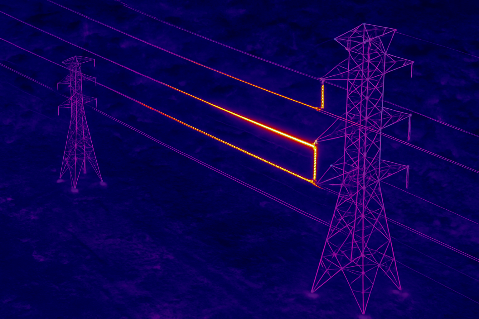
Electrical and Utility Inspections
For power lines, substations, transformers, and industrial sites, thermal drones help identify:
Overheated components
Insulator faults
Phase imbalance
Corrosion or material fatigue
Using drones eliminates the need for bucket trucks or shutdowns — minimizing downtime and keeping workers safely on the ground. With the Mavic 3T’s powerful zoom and thermal overlays, we can capture data from a safe distance with high accuracy.
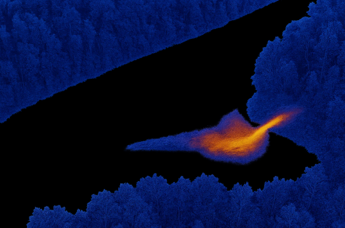
Wildlife and Environmental Monitoring
As part of our commitment to sustainability and the land we love, we also offer services for:
Wildlife tracking and recovery
Habitat surveys
Thermal mapping of sensitive ecosystems
Monitoring geothermal activity or water temperatures
Thermal drones allow researchers, conservationists, and agencies to monitor natural systems with less intrusion and greater insight.


Insurance Documentation & Claim Support
If your home, business, or property suffers damage — from fire, wind, flood, or anything else — thermal imaging can help insurance adjusters:
Accurately assess damage
Verify moisture intrusion
Detect fire damage or lingering hotspots
Validate repairs
We can provide objective, high-resolution thermal images to support or dispute claims — giving you more leverage during the claims process.
Why Choose Us for Thermal Drone Services in Montrose, Colorado?
We're not a national chain or a part-time hobbyist. We're a local, licensed, and experienced aerial media company with deep roots in Western Colorado.
When you work with us, you get:
✅ FAA Part 107 Certified Pilot
✅ Advanced Thermal Drone Technology (DJI Mavic 3T)
✅ Years of Flight & Camera Experience
✅ Fast Turnaround & Custom Reporting
✅ Local Knowledge of Terrain, Weather & Industry
✅ Full Insurance Coverage
Whether you need a one-time inspection, ongoing monitoring, or creative thermal videography, we deliver clear, actionable results — safely, legally, and professionally.
Deliverables & Workflow
Here’s how a typical thermal drone project works:
1. Consultation
We start with a free phone or in-person consultation to understand your goals, site, and timeline.
2. Flight Planning
We assess airspace, weather, site access, and safety — including any FAA waivers if necessary.
3. Aerial Data Capture
Using the DJI Mavic 3T, we fly the mission, capture both thermal and RGB imagery, and ensure full coverage.
4. Analysis & Reporting
Depending on the project, we can provide:
Thermal video and still images
Side-by-side thermal/RGB comparisons
Orthomosaic thermal maps
3D modeling or elevation data (available on request)
Interpreted reports highlighting areas of concern
5. Delivery
You’ll receive secure links or downloadable files in your preferred format, ready to use in reports, presentations, or documentation.
Pricing & Packages
We offer transparent pricing based on flight time, complexity, analysis level, and travel. Most projects fall into these ranges:
Service Starting Price:
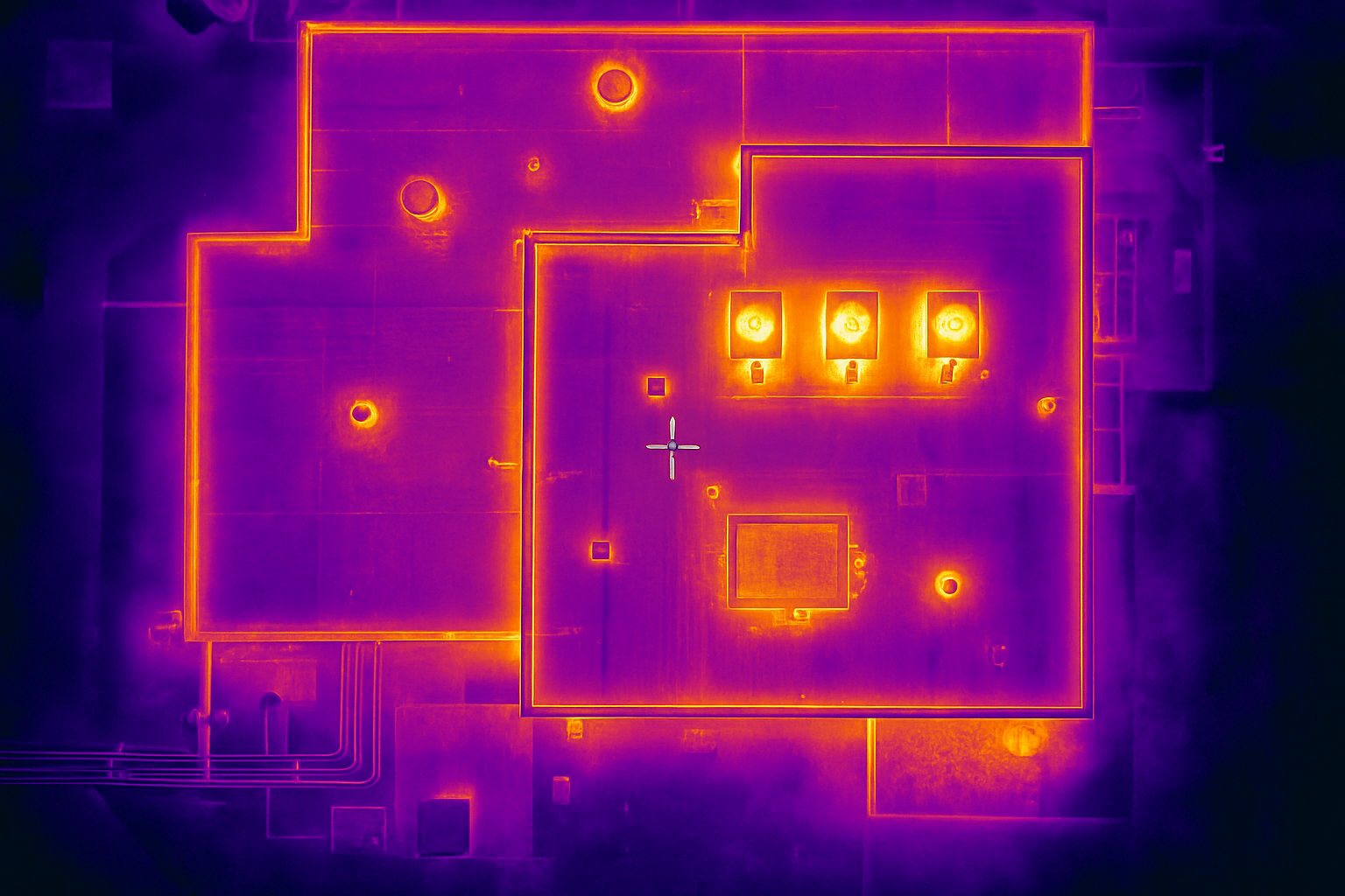
Basic Thermal Roof Scan $250
Residential Property Survey $300
Commercial Building Inspection $500
Solar Farm Inspection $450
Agricultural Field Scan $400
Emergency Callout (SAR, Fire) $200/hr
Custom quotes available. Discounts for recurring services or multi-site projects.
Serving Montrose & Beyond
We proudly serve clients across the Western Slope, including:
Montrose
Delta
Ridgway
Ouray
Gunnison
Grand Junction
Telluride
Cedaredge
Paonia
And more...
We’re mobile, flexible, and ready to travel for larger projects throughout Colorado and the Four Corners region.